Файл:Luhansk and Russia.svg
Материал из Циклопедии
Перейти к навигации
Перейти к поиску
Размер этого PNG-превью для исходного SVG-файла: 680 × 520 пкс. Другие разрешения: 314 × 240 пкс | 628 × 480 пкс | 1004 × 768 пкс | 1280 × 979 пкс | 2560 × 1958 пкс.
Исходный файл (SVG-файл, номинально 680 × 520 пкс, размер файла: 799 Кб)
Этот файл из на Викискладе и может использоваться в других проектах. Информация с его страницы описания приведена ниже.
Краткое описание
ОписаниеLuhansk and Russia.svg |
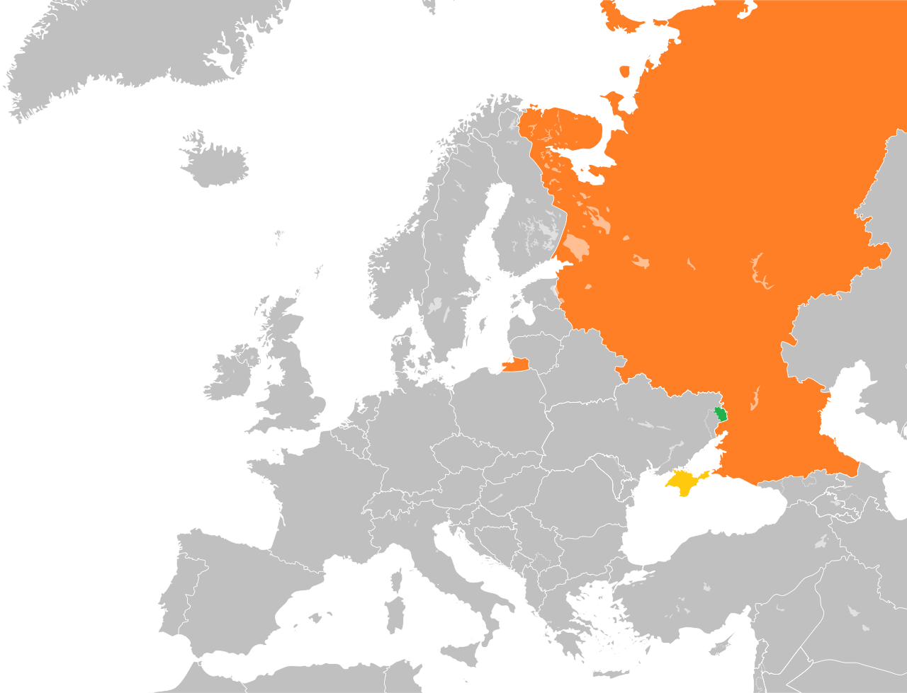
English: Map of Russia (orange) and the self-proclaimed Luhansk People's Republic (green). Crimea is coloured differently due to its disputed status. |
Дата | |
Источник | Собственная работа |
Автор | DystopianArk |
Лицензирование
Я, владелец авторских прав на это произведение, добровольно публикую его на условиях следующей лицензии:
Этот файл доступен на условиях Creative Commons CC0 1.0 Универсальной передачи в общественное достояние (Universal Public Domain Dedication). | |
Лица, связанные с работой над этим произведением, решили передать данное произведение в общественное достояние, отказавшись от всех прав на произведение по всему миру в рамках закона об авторских правах (а также связанных и смежных прав), в той степени, которую допускает закон. Вы можете копировать, изменять, распространять, исполнять данное произведение в любых целях, в том числе в коммерческих, без получения на это разрешения автора.
http://creativecommons.org/publicdomain/zero/1.0/deed.enCC0Creative Commons Zero, Public Domain Dedicationfalsefalse |
Элементы, изображённые на этом файле
изображённый объект
У этого свойства есть некоторое значение без элемента в
23 февраля 2022
История файла
Нажмите на дату/время, чтобы увидеть версию файла от того времени.
Дата/время | Миниатюра | Размеры | Участник | Примечание | |
---|---|---|---|---|---|
текущий | 11:13, 23 февраля 2022 | 680 × 520 (799 Кб) | wikimediacommons>DystopianArk | Uploaded own work with UploadWizard |
Использование файла
Следующая страница использует этот файл:
Метаданные
Файл содержит дополнительные данные, обычно добавляемые цифровыми камерами или сканерами. Если файл после создания редактировался, то некоторые параметры могут не соответствовать текущему изображению.
Краткое название | Countries of Europe |
---|---|
Название изображения | A blank Map of Europe. Every country has an id which is its ISO-3166-1-ALPHA2 code in lower case.
Members of the EU have a class="eu", countries in europe (which I found turkey to be but russia not) have a class="europe". Certain countries are further subdivided the United Kingdom has gb-gbn for Great Britain and gb-nir for Northern Ireland. Russia is divided into ru-kgd for the Kaliningrad Oblast and ru-main for the Main body of Russia. There is the additional grouping #xb for the "British Islands" (the UK with its Crown Dependencies - Jersey, Guernsey and the Isle of Man) and the Kingdom of Denmark (Denmark, Faroe Islands, Greenland) Contributors. Original Image: (http://commons.wikimedia.org/wiki/Image:Europe_countries.svg) Júlio Reis (http://commons.wikimedia.org/wiki/User:Tintazul). Recolouring and tagging with country codes: Marian "maix" Sigler (http://commons.wikimedia.org/wiki/User:Maix) Improved geographical features: http://commons.wikimedia.org/wiki/User:W!B: Updated to reflect dissolution of Serbia & Montenegro: http://commons.wikimedia.org/wiki/User:Zirland Updated to include British Crown Dependencies as seperate entities and regroup them as "British Islands", with some simplifications to the XML and CSS: James Hardy (http://commons.wikimedia.org/wiki/User:MrWeeble) Validated (http://commons.wikimedia.org/wiki/User:CarolSpears) Changed the country code of Serbia to RS per http://en.wikipedia.org/wiki/Serbian_country_codes and the file http://www.iso.org/iso/iso3166_en_code_lists.txt (http://commons.wikimedia.org/wiki/User:TimothyBourke) Uploaded on behalf of User:Checkit, direct complaints to him plox: 'Moved countries out of the "outlines" group, removed "outlines" style class, remove separate style information for Russia' (http://commons.wikimedia.org/wiki/User:Collard) Updated various coastlines and boarders and added various islands not previously shown (details follow). Added Kosovo, Northern Cyprus, Crimea, Abkhazia, South Ossetia, Transnistria and Nagorno-Karabakh as disputed territories. Moved major lakes to their own object and added more. List of updated boarders/coastlines: British Isles (+ added Isle of Wight, Skye, various smaller islands), the Netherlands, Germany, Austria, Hungary, Czech Republic, Denmark, Sweden, Finland, Poland, Kaliningrad Oblast of the Russian Federation (and minor tweaks to Lithuania), Estonia, Ukraine, Moldova (minor), Romania, Bulgaria, Turkey, Greece, F.Y.R. Macedonia, Serbia, Bosnia and Herzegovina, Montenegro, Albania, Croatia, Italy (mainland and Sicily), Malta (http://commons.wikimedia.org/wiki/User:Alphathon). Added Bornholm (http://commons.wikimedia.org/wiki/User:Heb)Released under CreativeCommons Attribution ShareAlike (http://creativecommons.org/licenses/by-sa/2.5/). |
Ширина | 680 |
Высота | 520 |