Файл:Time zones of Europe.svg
Перейти к навигации
Перейти к поиску

Размер этого PNG-превью для исходного SVG-файла: 512 × 523 пкс. Другие разрешения: 235 × 240 пкс | 470 × 480 пкс | 752 × 768 пкс | 1002 × 1024 пкс | 2005 × 2048 пкс.
Исходный файл (SVG-файл, номинально 512 × 523 пкс, размер файла: 332 Кб)
Краткое описание
| Описание |
Беларуская: Карта гадзінных паясоў Еўропы
Беларуская (тарашкевіца): Мапа гадзінавых пасаў Эўропы
Čeština: Mapa časových pásem v Evropě
Dansk: Kort over Europas tidszoner
Deutsch: Karte der Zeitzonen Europas
Westeuropäische Zeit (UTC±0)
Westeuropäische Zeit (UTC±0) / Westeuropäische Sommerzeit (UTC+1)
Mitteleuropäische Zeit (UTC+1) / Mitteleuropäische Sommerzeit (UTC+2)
Kaliningrader Zeit (UTC+2)
Osteuropäische Zeit (UTC+2) / Osteuropäische Sommerzeit (UTC+3)
Moskauer Zeit / Türkei Zeit (UTC+3)
Eesti: Euroopa ajavööndite kaart
Ελληνικά: Χάρτης των χρονικών ζωνών της Ευρώπης
English: Map of the time zones of Europe
Español: Mapa de los husos horarios de Europa
Esperanto: Mapo de Eŭropo-horzonoj
Français : Carte des fuseaux horaires de l'Europe
Italiano: Mappa dei fusi orari dell'Europa
ქართული: ევროპის სასაათო ზონების რუკა
Latina: Tabula Europae tempus zonae
Latviešu: Eiropas kartē laika zonām
Lietuvių: Europos žemėlapis laiko zonų
Magyar: Európa időzónák térképe
Nederlands: Kaart van de tijdzones in Europa
Norsk bokmål: Kart over tidssoner i Europa
Polski: Mapa stref czasowych Europy
Português: Mapa dos fusos horários da Europa
Русский: Карта часовых поясов в Европе
Slovenčina: Mapa časových pásiem Európy
Slovenščina: Zemljevid časovnih pasov Evrope
Suomi: Euroopan kartta aikavyöhykkeiden
Svenska: Karta över Europas tidszoner
Українська: Мапа часових поясів Європи
日本語: ヨーロッパの時間帯の地図
中文(简体):欧洲的时区地图
中文(繁體):歐洲的時區地圖 |
| Дата | (UTC) |
| Источник | Based on Blank map of Europe.svg, source: Time zones of Europe.png; |
| Автор | maix |
| Другие версии |
|
| SVG‑разработка |


.svg)


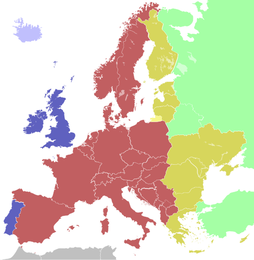
Colours
| Light blue | Western European Time / Greenwich Mean Time (UTC) |
| Blue | Western European Time / Greenwich Mean Time (UTC) Western European Summer Time (UTC+1) |
| Red | Central European Time (UTC+1) Central European Summer Time (UTC+2) |
| Yellow | Eastern European Time / Kaliningrad Time (UTC+2) |
| Golden | Eastern European Time (UTC+2) Eastern European Summer Time (UTC+3) |
| Light green | Further-eastern European Time / Moscow Time / Turkey Time (UTC+3) |
| Light colours indicate where standard time is used all year; dark colours indicate where a summer time (also known as "daylight saving time" or "DST") is used. | |
Лицензирование
Я, владелец авторских прав на это произведение, добровольно публикую его на условиях следующих лицензий:
Этот файл размещён на условиях Creative Commons «С сохранением условий 1.0».
|

|
Это произведение — свободное программное обеспечение; вы можете распространять и/или изменять его в соответствии с условиями GNU General Public License, опубликованной Free Software Foundation, версии 2 или более поздней. Данное произведение распространяется в надежде на то, что оно будет полезным, но без какой-либо гарантии; в том числе, без подразумеваемых гарантий товарной пригодности или пригодности для конкретных целей. Подробнее см. версию 2 и версию 3 условий GNU General Public License. |
Вы можете выбрать любую из этих лицензий.
История файла
Нажмите на дату/время, чтобы увидеть версию файла от того времени.
| Дата/время | Миниатюра | Размеры | Участник | Примечание | |
|---|---|---|---|---|---|
| текущий | 13:10, 12 октября 2023 | | 512 × 523 (332 Кб) | wikimediacommons>3.kor0p | Reverted to version as of 23:01, 2 August 2021 (UTC). Crimea is part of Ukraine |
Использование файла
Следующие 4 страницы используют этот файл: